Boudreau LogicResearch & InvestigationLand Patent Research
The Land Beneath the Courthouse
Tracing the original Indian allotment patent of the land where the Mahnomen County Courthouse now stands — and the troubling timeline it reveals.
Boudreau Logic · White Earth, Minnesota · February 2026
The Mahnomen County Courthouse has stood at 311 North Main Street in Mahnomen, Minnesota since 1909. It is a Classical Revival brick building that serves as the seat of county government. But a review of federal land patent records raises a serious question: was the courthouse built on land that was still held in federal trust for a White Earth Ojibwe allottee?
Using the Bureau of Land Management's General Land Office (GLO) records, ArcGIS mapping tools, and the Public Land Survey System (PLSS), we traced the original patent holders for Section 2, Township 144 North, Range 41 West, 5th Principal Meridian — the area where the city of Mahnomen is situated. What we found was a timeline that doesn't add up.
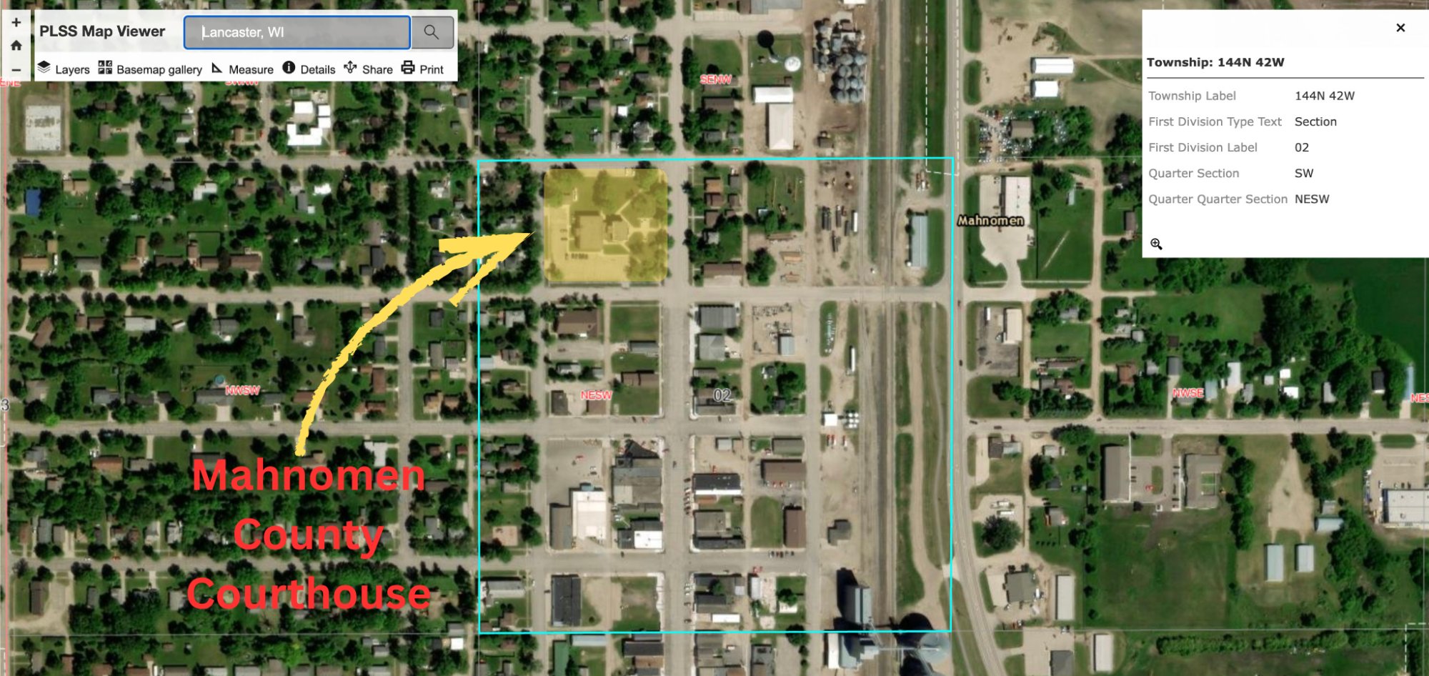
PLSS Map Viewer — ArcGIS satellite view showing the Mahnomen County Courthouse (highlighted in yellow) located within the NE¼ SW¼ of Section 02. The panel at right confirms: Township 144N 42W, Section 02, Quarter Section SW, Quarter Quarter Section NESW.
Research Note
Based on our analysis of available PLSS data and BLM patent records, we believe the Mahnomen County Courthouse sits on or near the NE¼ of the SW¼ of Section 2, T144N, R41W, 5th PM — land originally patented to Frank Glass. However, we have not conducted a professional land survey or title search to confirm this with absolute certainty. The ArcGIS PLSS data shows the courthouse within Section 2 at the NE¼ SW¼ quarter-quarter, which aligns with Frank Glass's patent. This research presents a reasonable conclusion based on the available evidence and warrants further verification through official county and federal records.
The Allottee: Frank Glass
Frank Glass was a Chippewa Indian belonging to the White Earth Reservation. Under the General Allotment Act of 1887 (the Dawes Act) and the Act of January 14, 1889, Glass was allotted land in Section 2 of what would become the city of Mahnomen.
On December 30, 1902, President Theodore Roosevelt signed Trust Patent No. 3005, granting Frank Glass the following described land:
Federal Trust Patent — Document No. 3005
No. 3005 · Letter No. B 70528-19 · Patent No. 72117
The United States of America
To all to whom these presents shall come, Greeting
AllotteeFrank Glass
Tribal AffiliationChippewa Indian, White Earth Reservation
The trust patent meant the federal government held legal title to the land for Glass's benefit. Under its terms, the land could not be sold, transferred, taxed, or encumbered for a period of twenty-five years — meaning trust protections would not expire until approximately 1927.
Original Document — Trust Patent (1902)
Signed by President Theodore Roosevelt, December 30, 1902
Section 2 Allottees
Frank Glass was not the only allottee in Section 2. The BLM GLO records show multiple Chippewa allottees received patents for land in this section, all dated in 1902:
Allottee
Date
Aliquot(s) in Sec. 2
Doc #
Mable Darco
7/21/1902
NW¼ SE¼
69
William Beaulieu
7/21/1902
SW¼ NE¼, SE¼ NW¼
72
Georgina Branchaud
7/21/1902
Lot/Tract 1
158
Maysh Ko We Gah Bow
12/30/1902
S½ SE¼, SE¼ NE¼, NE¼ SE¼
2323, 2352
Frank Glass
12/30/1902
Lot 4, NE¼ SW¼
3005
Cynthia E. Glass
12/30/1902
Lot 2, Lot 3
3006
Leonora Glass
12/30/1902
SE¼ SW¼
3007
Lucy Merrell
12/30/1902
NW¼ SW¼, SW¼ NW¼
3472
Daniel Sullivan
12/30/1902
SW¼ SW¼
3695
The Glass family — Frank, Cynthia E., and Leonora — held a significant block of allotments in the southwest portion of Section 2, forming a family allotment cluster that was common practice during the allotment era.
Section 2 — SW Quarter Detail
NW¼ NW¼
NE¼ NW¼
NW¼ NE¼
NE¼ NE¼
SW¼ NW¼ Merrell
SE¼ NW¼ Beaulieu
SW¼ NE¼ Beaulieu
SE¼ NE¼ M.K.W.G.B.
NW¼ SW¼ Merrell
NE¼ SW¼ F. Glass
NW¼ SE¼ Darco
NE¼ SE¼ M.K.W.G.B.
SW¼ SW¼ Sullivan
SE¼ SW¼ L. Glass
SW¼ SE¼ M.K.W.G.B.
SE¼ SE¼ M.K.W.G.B.
Believed courthouse location (F. Glass)
Glass family allotments
Section 2, T144N R41W, 5th PM — Approximate allotment layout based on BLM GLO records. M.K.W.G.B. = Maysh Ko We Gah Bow.
The Timeline Problem
This is where the story becomes troubling. Consider the following sequence of events:
1887
February 8, 1887
Dawes Act Signed Into Law
The General Allotment Act authorizes the President to divide tribal lands into individual allotments. Trust patents are issued for 25 years, during which the land cannot be sold, transferred, or taxed.
1902
December 30, 1902
Trust Patent Issued to Frank Glass
President Theodore Roosevelt signs Trust Patent No. 3005, allotting Lot 4 and the NE¼ SW¼ of Section 2 to Frank Glass. The land is held in trust for 25 years — protections would not expire until approximately 1927.
1906
May 8, 1906
Mahnomen County Established
Mahnomen County is officially organized. The county seat is established in the city of Mahnomen.
1909
Circa 1909–1910
Courthouse Built on Trust Land
The Mahnomen County Courthouse is constructed at 311 North Main Street, on land that — according to federal patent records — was still held in trust for Frank Glass. The trust period had 18 years remaining. The building cost approximately $9,763.
1917
April 17, 1917
Sells "Declaration of Policy"
Commissioner of Indian Affairs Cato Sells issues a declaration that accelerates the issuance of fee simple patents to allottees, often without their consent or request. This policy leads to widespread land loss across Indian Country.
1919
November 26, 1919
Fee Simple Patent Issued
President Woodrow Wilson signs a fee simple patent for Frank Glass's land, removing all trust protections eight years early. The land becomes subject to taxation, sale, and transfer. Patent No. 72117 is recorded — the same land, the same allottee, but now with no federal protections.
The Central Question
If the Mahnomen County Courthouse was built in 1909, and Frank Glass's land was not converted from trust to fee simple until 1919, then the county constructed a government building on federally protected Indian trust land — a full decade before the land was legally available for such use.
Original Document — Fee Simple Patent (1919)
Signed by President Woodrow Wilson, November 26, 1919 — converting the trust patent to fee simple ownership
What This Means
Under the terms of the 1902 trust patent, Frank Glass's allotment was held by the United States government for his sole use and benefit. During the trust period, the land was under federal — not state or county — jurisdiction. No state or county government should have been able to acquire, condemn, or build upon this land without explicit federal authorization.
The trust patent stated clearly that the land was held "in trust for the sole use and benefit of the said Frank Glass" and that the President could, at his discretion, extend the trust period. There was no provision in the patent for county acquisition or construction of government buildings.
The issuance of the fee simple patent in 1919 — ten years after the courthouse was already standing — raises the question of whether this conversion was done specifically to retroactively legitimize the county's use of the land. The 1919 patent was issued during the height of the "forced fee" era, when the federal government aggressively converted trust allotments to fee simple status, often without the allottee's knowledge or consent.
Unanswered Questions
This research opens several questions that warrant further investigation:
Did the federal government authorize the county's use of Frank Glass's trust land before the courthouse was built in 1909?
Was there a condemnation proceeding, land exchange, or other legal mechanism used to acquire the land?
Did Frank Glass consent to the use of his allotment for a county building?
Was the 1919 fee simple patent issued at the request of Glass, or was it a "forced fee" patent issued without his consent?
Are there county records, federal correspondence, or Bureau of Indian Affairs files from 1906–1919 that document how this land was acquired?
What are the legal implications today, given the documented timeline?
Historical Context: The Allotment Era
The Dawes Act of 1887 was one of the most devastating federal policies in the history of Indian Country. Under the guise of "civilizing" Native Americans and promoting individual land ownership, the Act broke up communal tribal lands into individual allotments. "Surplus" lands — often the majority of the reservation — were then opened to non-Indian settlement.
At White Earth, the allotment process was further compounded by the Nelson Act of 1889 and subsequent legislation that consolidated Minnesota Chippewa bands onto the White Earth Reservation. The result was a dramatic transfer of land from Ojibwe ownership to non-Indian ownership over the following decades.
The Burke Act of 1906 gave the Secretary of the Interior the power to issue fee simple patents before the 25-year trust period expired, supposedly to "competent" allottees. In practice, this was used as a tool to accelerate land dispossession. Commissioner Cato Sells' 1917 "Declaration of Policy" further accelerated this process by directing fee patents be issued to allottees deemed "competent" — often based solely on blood quantum rather than any actual assessment of the individual's circumstances.
Nationally, Indian land holdings decreased from approximately 138 million acres in 1887 to roughly 48 million acres by 1934, when the Indian Reorganization Act finally ended the allotment policy. At White Earth, the impacts were particularly severe.
Sources
Bureau of Land Management, General Land Office Records — glorecords.blm.gov
Trust Patent No. 3005, Frank Glass, December 30, 1902 (President Theodore Roosevelt) — View PDF
Fee Simple Patent No. 72117, Frank Glass, November 26, 1919 (President Woodrow Wilson) — View PDF
BLM PLSS Data via ArcGIS — Section 2, T144N, R41W, 5th Principal Meridian
Mahnomen County Courthouse, National Register of Historic Places (listed 1984)
MnDOT General Highway Map, Mahnomen County
Disclaimer
This page presents preliminary research based on publicly available federal land patent records and GIS data. While we believe Frank Glass's allotment (NE¼ SW¼, Section 2, T144N, R41W) is the most likely location of the Mahnomen County Courthouse, we have not conducted a professional land survey or title search to confirm this with certainty. The exact quarter-quarter section the courthouse occupies should be verified through official county records and modern survey data. This research is intended to raise questions for further investigation, not to make definitive legal claims.